Brought to Light was curated by Geraldine Bobsien and was shown at the John Paynter Gallery in 2010.
Brought to Light: Hidden Newcastle Revealed is an exhibition related to three hidden sites located throughout Newcastle, NSW. The project hinges around the collaboration of several cultural practitioners: artist Darren Siwes, poet and writer Mark Treddinick, and visual artist Matthew Tome.
http://www.thelockup.info/brought-to-light
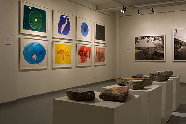
I was responding to the canoe pool at Newcastle Baths. The works are based on the myth that under the canoe pool is a mosaic map of the world. I wanted to conduct a kind of archaeological artwork, where the material to support the myth is discovered. The historical reality is not as complex but just as interesting.
The fragments of tiles are remnants of the mosaic map of the world. They are of their time, not as ornate as a byzantine mosaic (this is not Ravenna after all) but not slick and modern either. They are perhaps the product of a civic folly, an amateur tribute of massive scale. A few visitors to the exhibition took them to be real and wondered how I was allowed to take them and display them.
The video work is of the children archaeologists finding fragments of the map, digging with plastic spades in the sand, unearthing the mythical mosaic. It is edited as a looped cycle, the cycle is like the repetitive search, sifting for sand, hoping.
The watercolours and drawings are speculations, conjectures and projections. A map is a complex image and reveals much about the mind that created it. Whether the map depicts geological forms, political relations, describes natural resources or maps heat, ice, oil or the stars it is a revelation of a mind that conceived it.
Any map of the world on a flat surface is a distortion, a deliberate error that attempts to depict the surface of a sphere. Was the map centred on Australia, how were the landforms depicted if at all, did the map indicate political differences -was the British Empire pink? Did the map describe more sinister aspects of the past – the military blocs, the doomsday map of the missile distance between major cities? Or was it more poetic – a map which mirrored the night sky above it? Perhaps it predicted the future and saw our destiny, climate change, erosion, rising seas.